Railroads, highways and other man-made lines racially divide America’s cities
Published 5:01 pm Friday, July 17, 2015
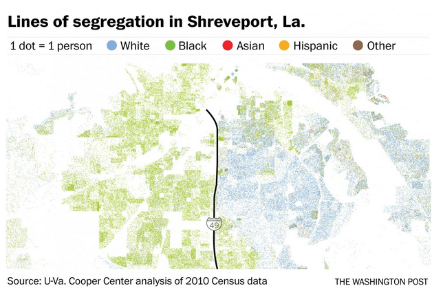
- Shreveport, Louisiana
Like many metaphors, “the other side of the tracks” was originally a literal epithet. Blacks were often historically restricted to neighborhoods separated from whites by railroads, turning the tracks into iron barriers of race and class.
In many cities, these dividing lines persist to this day – a reflection of decades of discriminatory policies and racism, but also of the power of infrastructure itself to segregate.
Trending
Look at racial maps of many American cities, and stark boundaries between neighboring black and white communities frequently denote an impassable railroad or highway, or a historically uncrossable avenue. Infrastructure has long played this role: reinforcing unspoken divides, walling off communities, containing their expansion, physically isolating them from schools or parks or neighbors nearby.
Research, in fact, suggests that U.S. cities that were subdivided by railroads in the 19th century into physically discrete neighborhoods became much more segregated decades later following the Great Migration of blacks out of the rural South.
You can see echoes of that pattern in Hartford, Connecticut, today on this map drawn using the racial dot map created by Dustin Cable at the University of Virginia’s Weldon Cooper Center for Public Service. Railroads there have historically amplified neighborhood divisions created by the city’s hilly topography.
A century after many of those railroads were built, the pattern was repeated in a modern form: through the construction of even more imposing highways, many of which both destroyed and separated minority neighborhoods. Local roads formed barriers, too. Banks refused to lend to homeowners on one side of many of these lines. School attendance zones were divided, too, as were other man-made lines of disparity.
Trending
-
eEdition
-
-
